

Aventis Energy Announces Exploration Plans at its Corvo Uranium Project
/EIN News/ -- VANCOUVER, British Columbia, June 09, 2025 (GLOBE NEWSWIRE) -- Aventis Energy Inc. (“Aventis” or the “Company”) (CSE: AVE | FRA: C0O0 | OTC: VBAMF), is pleased to provide a summary of 2025 exploration programs planned on its Corvo Uranium Project (the “Corvo Property”, or the “Project”).
Highlights:
- High-grade* Uranium at Surface: A prospecting, mapping, and geochemical sampling program is planned for July 2025 to ground-truth historical uraniferous outcrops including the Manhattan showing (1.19 to 5.98% U3O8) and SMDI showing 2052 (0.137% U3O8 and 2,300 ppm Th).1
- High-Resolution Geophysics: An extensive ground gravity survey is being planned for Q4 2025, designed to identify density anomalies potentially representing hydrothermal alteration systems coincident with newly refined electromagnetic (“EM”) conductor trends across the Project.
- Integrated Target Development: The results of the recent airborne TDEM survey2 and the planned ground gravity survey will be subject to geophysical inversion, interpretation, and modelling, and integrated with the Project’s existing datasets, to prioritize target areas for inaugural drilling.
- Inaugural Drill Program: A diamond drill program is being planned for Q1 2026 to begin testing targets developed and ranked through the detailed programs that will be executed in 2025.
Mandeep Parmar, Interim Chief Executive Officer & Director of the Company, commented, “Recently obtained data from the Project gathered via a TDEM survey will significantly heighten the Company’s technical understanding of the Project once modeled and integrated with existing datasets. The new data will enable the Company to prioritize target areas for a future drilling program. We are eager to drive tangible advancement on the Project and we remain committed to advancing the Corvo Property.”
2025 Exploration Plans
Earlier this year, Standard Uranium Ltd. contracted Axiom Exploration Group Ltd. in partnership with New Resolution Geophysics to carry out a helicopter-borne Xcite time domain electromagnetic and total field magnetic survey over the Corvo Property. The survey totalled approximately 1,380 line-kms with a traverse line spacing of 100 m and tie-line spacing of 1,000 m. The airborne TDEM survey outlines several kilometers of conductive anomalies and magnetic features in bedrock, effectively enhancing the resolution of the conductive trends on the Project.
The magnetic survey component of the TDEM survey contributes to definition of potential fault systems and structural trends not previously identified across the Project related to historical uranium showings at surface and in historical drill holes.
The Company will undertake a detailed mapping, prospecting, and sampling program to ground-truth historical uranium showings at surface in early July 2025. Samples will be shipped to Saskatchewan Research Council Geoanalytical Laboratories in Saskatoon, SK for geochemical analysis. Results will be released and incorporated into the NI 43-101 technical report on the Project.
Supplementary geophysical surveys across the Project are being designed to further refine drill targets for an inaugural drill program. The Company plans to complete a high-resolution ground gravity survey across the main conductive trends on the Project, aiming to identify potential hydrothermal alteration halos which could be related to basement-hosted uranium mineralization.
Ongoing geophysical interpretation and modeling is planned throughout 2025 to integrate historical surveys with newly collected datasets, which will provide high-priority drill targets and significantly derisk the Project prior to the anticipated modern drilling next year.
The Company believes the Project is highly prospective for the discovery of shallow, high-grade basement-hosted uranium mineralization akin to the Rabbit Lake deposit and the recently discovered Gemini Mineralized Zone. Located just outside the current margin of the Athabasca Basin, the Corvo Property boasts shallow drill targets with bedrock under minimal cover of glacial till. Several outcrop showings of mineralized veins and fractures are present on the Project, notably the Manhattan Showing that returned a historical grab sample with results of 59,800 ppm U at surface1 and has never been drill tested.
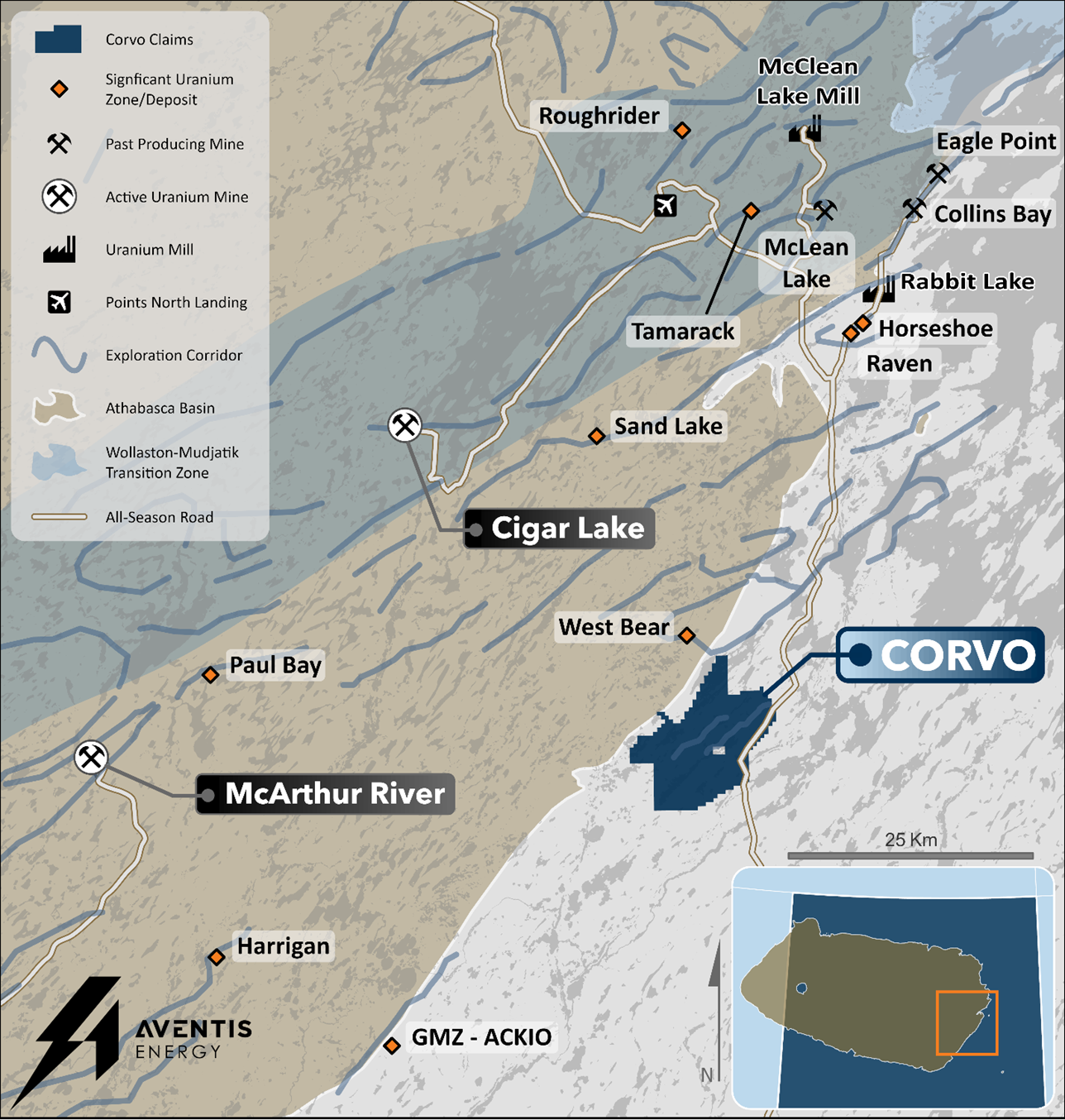
Figure 1. Regional map of the Corvo Project. The Project is located 45 km northeast of Atha Energy’s Gemini Mineralized Zone (“GMZ”) and 60 km due east of Cameco’s McArthur River mine.

Figure 2. Summary map showing low/EM conductor trends on the Corvo Property and highlighting historical samples and drill holes with anomalous uranium and/or radioactivity, with first vertical derivative magnetics in the background.
*The Company considers uranium mineralization with concentrations greater than 1.0 wt% U3O8 to be “high-grade”.
**The Company considers radioactivity readings greater than 300 counts per second (cps) to be “anomalous”.
Qualified Person Statement
The scientific and technical information contained in this news release has been reviewed, verified, and approved by Sean Hillacre, P.Geo., President and VP Exploration of Standard Uranium Ltd. and a “qualified person” as defined in NI 43-101 – Standards of Disclosure for Mineral Projects.
Historical data disclosed in this news release relating to sampling results from previous operators are historical in nature. Neither the Company nor a qualified person has yet verified this data and therefore investors should not place undue reliance on such data. The Company’s future exploration work may include verification of the data. The Company considers historical results to be relevant as an exploration guide and to assess the mineralization as well as economic potential of exploration projects. Any historical grab samples disclosed are selected samples and may not represent true underlying mineralization.
References
1 SMDI# 2052: https://mineraldeposits.saskatchewan.ca/Home/Viewdetails/2052 & Mineral Assessment Report MAW00047: Eagle Plains Resources Inc., 2011-2012.
2 Standard Uranium Provides Exploration Update Highlighting Results of Gravity and TDEM Surveys on Three Eastern Athabasca Uranium Projects, News Release, March 13, 2025. https://standarduranium.ca/news-releases/standard-uranium-provides-exploration-update-tdem-surveys-on-three-eastern-athabasca-uranium/.
About Aventis Energy Inc.
Aventis Energy Inc. (CSE: AVE | FRA: C0O0 | OTC: VBAMF) is a mineral exploration company dedicated to the development of strategic projects comprised of battery, base and precious metals in stable jurisdictions. The Company is working to advance its Corvo Uranium & Sting Copper Project.
The Corvo Uranium property has historical drill holes intersected multiple intervals of uranium mineralization, notably along a strike length of 800 metres between historical drill holes TL-79-3 (0.116% U3O8 over 1.05 m) and TL-79-5 (0.065% U3O8 over 0.15 m)2. High-grade* Uranium at Surface with the Manhattan showing (1.19 to 5.98% U3O8) and SMDI showing 2052 (0.137% U3O8 and 2,300 ppm Th).
The Sting Copper Project covers approximately 12,700 hectares and recently had results of 54.8m at 0.32% Cu starting at a depth of 27.0m, with higher-grade intervals including six samples (≥0.5m length) ranging from 0.96% to 5.43% Cu. High grade samples of 0.5m at 2.85% Cu and 0.5m at 1.92% Cu with an additional broader interval of 31.1m at 0.27% Cu.
References
Mineral Assessment Report 64E13-0054: Norbaska Mines Ltd., 1979-1980.
SMDI# 2052: https://mineraldeposits.saskatchewan.ca/Home/Viewdetails/2052 & Mineral Assessment Report MAW00047: Eagle Plains Resources Inc., 2011-2012.
Vital Battery Metals Drills 20.5m of 1.21% Cu Including 5.0m of 2.22% Cu at Sting Copper Project., News Release, January 14, 2025. https://www.globenewswire.com/news-release/2025/01/14/3009258/0/en/Vital-Battery-Metals-Drills-20-5m-of-1-21-Cu-Including-5-0m-of-2-22-Cu-at-Sting-Copper-Project.html.
On Behalf of the Board of Directors
Mandeep Parmar
Interim Chief Executive Officer, Director
+1 (604) 229-9772
info@vitalbatterymetals.com
Disclaimer for Forward-Looking Information
Certain statements in this news release are forward-looking statements, including with respect to future plans, and other matters. Forward-looking statements consist of statements that are not purely historical, including any statements regarding beliefs, plans, expectations or intentions regarding the future. Such information can generally be identified by the use of forwarding-looking wording such as "may", "expect", "estimate", "anticipate", "intend", "believe" and "continue" or the negative thereof or similar variations. The reader is cautioned that assumptions used in the preparation of any forward-looking information may prove to be incorrect. Events or circumstances may cause actual results to differ materially from those predicted, as a result of numerous known and unknown risks, uncertainties, and other factors, many of which are beyond the control of the Company, including but not limited to, business, economic and capital market conditions, the ability to manage operating expenses, and dependence on key personnel. Forward looking statements in this news release include, but are not limited to, statements with respect to the Project and its mineralization potential; the Company’s objectives, goals, or future plans with respect to the Project; and the Company's anticipated exploration programs at the Project. Such statements and information are based on numerous assumptions regarding present and future business strategies and the environment in which the Company will operate in the future, anticipated costs, and the ability to achieve goals. Factors that could cause the actual results to differ materially from those in forward-looking statements include, the continued availability of capital and financing, litigation, failure of counterparties to perform their contractual obligations, loss of key employees and consultants, and general economic, market or business conditions. Forward-looking statements contained in this news release are expressly qualified by this cautionary statement. The reader is cautioned not to place undue reliance on any forward-looking information.
The Canadian Securities Exchange (CSE) does not accept responsibility for the adequacy or accuracy of this release.
Photos accompanying this announcement are available at:
https://www.globenewswire.com/NewsRoom/AttachmentNg/62fc991c-367f-4d78-bc3a-36cc75516f76
https://www.globenewswire.com/NewsRoom/AttachmentNg/c123756f-0a9a-4240-be45-1794768004c2


Figure 1
Regional map of the Corvo Project. The Project is located 45 km northeast of Atha Energy’s Gemini Mineralized Zone (“GMZ”) and 60 km due east of Cameco’s McArthur River mine.
Figure 2
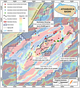
Summary map showing low/EM conductor trends on the Corvo Property and highlighting historical samples and drill holes with anomalous uranium and/or radioactivity, with first vertical derivative magnetics in the background.
Distribution channels: Mining Industry ...
Legal Disclaimer:
EIN Presswire provides this news content "as is" without warranty of any kind. We do not accept any responsibility or liability for the accuracy, content, images, videos, licenses, completeness, legality, or reliability of the information contained in this article. If you have any complaints or copyright issues related to this article, kindly contact the author above.
Submit your press release