

White Gold Corp. Encounters Broad Near Surface Gold-Bearing Structure with High Density Quartz Veining in All Holes on Newly Discovered 2.2 km+ Chris Creek Gold Target
/EIN News/ -- TORONTO, Feb. 27, 2025 (GLOBE NEWSWIRE) -- White Gold Corp. (TSX.V: WGO, OTCQX: WHGOF, FRA: 29W) (the "Company") announces results of 2024 exploration diamond drilling programs at the QV and Betty properties located in the White Gold District, west-central Yukon, Canada. The initial diamond drilling program at the Chris Creek target encountered a broad near surface gold-bearing structure injected with high density quartz veining and silica flooding. The Chris Creek target is located in close proximity to the Company’s flagship White Gold project which includes 17.6 million tonnes averaging 2.12 g/t Au for 1,203,000 ounces of gold in the Indicated Resource category and 24.4 million tonnes averaging 1.42 g/t Au for 1,116,600 ounces of gold in the Inferred Resource category (1).
A detailed video overview by Management of the 2024 Chris Creek diamond drilling results can be found here: https://www.youtube.com/watch?v=4TTgRhtYQpM
“The drill results on the grass roots Chris Creek target successfully confirmed the presence of a thick zone of gold mineralization in a favourable host rock over the 400 m strike length tested on this newly discovered and very large target, which has been now been traced for more than 2.2 km and remains open for expansion, with the highest gold-in-soil values to date encountered right on the western edge of the target. Its close proximity and similarities to our flagship Golden Saddle deposit make it a very interesting opportunity. Furthermore, the target forms part of a larger 5.2 km mineralized trend which hosts other prospective targets that have seen minimal exploration and no drilling to date. The Chris Creek target is just one of numerous grass roots gold and critical mineral targets in our district scale portfolio complimenting our robust flagship deposit which is one of the highest-grade open pit gold resources in Canada of its size or greater owned by an exploration company. We look forward to continuing to advance this target, amongst our other targets to fully unlock the gold and critical mineral potential in this prolific district,” stated David D’Onofrio, CEO.
“We are encouraged with this initial round of shallow drilling at the Chris Creek target” stated Terry Brace, VP Exploration. “Our technical team is particularly impressed by the apparent size of the target in terms of strike length, thickness and continuity, as well as the density of quartz veining and silicification within the brittlely deformed intrusive host rocks. The target warrants additional drill testing with a goal of identifying areas of additional higher-grade gold mineralization.”
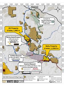
At the QV property, a maiden diamond drilling program comprising six holes totaling 1,082 m tested an approximately 400 m strike length of the near surface portion of the recently discovered Chris Creek gold target which has a soil geochemical signature similar to the Golden Saddle and VG deposits. At the Betty property, six holes totaling 1,130.8 m tested three separate gold targets – Black Betty, Betty White East and Betty Ford (Figure 1).
Maps and images accompanying this news release can be found at http://whitegoldcorp.ca/investors/exploration-highlights/.
Highlights:
QV Property, Chris Creek Target
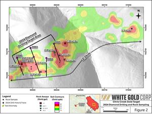
- 6 shallow diamond drill holes totaling 1,082 m were drilled at the Chris Creek target, testing an approximately 400 m strike length of the gold-in-soil anomaly which measures 2.2 km+ long and is open along strike to the east and west.
- All holes intersected gold mineralization within a gently dipping near surface broad brittle fractured structure up to approximately 50 m in width with associated stockwork quartz – tourmaline and carbonate – hematite veins/veinlets within potassically altered monzogranite intrusive host rocks, which remains open to the east, west and at depth.
- Anomalous silver and tellurium are associated with gold, which represents a geochemical signature similar to the VG and Golden Saddle deposits which both form part of the Company’s flagship White Gold Project.
- Initial drilling indicates the gold mineralized zone has continuity both along strike and down-dip and is open in all directions.
- Future work will focus on following up and expanding exploration on this newly discovered target to identify regions of the structure hosting high-grade gold lodes.
- The Chris Creek target forms part of a larger property-scale mineralized system on the QV property which measures 5.2 km+ in strike, with multiple other prospective targets which have not been drill tested.
Betty Property
- 6 diamond drill holes totaling 1,130.8 m were drilled on the Betty property, testing three separate targets, including Black Betty , Betty White East and Betty Ford.
- Drilling at Black Betty and Betty White East confirmed the structural interpretation with holes intersecting numerous faults, shear and breccia zones.
Regional Program
- Regional explorational results for several of the Company’s critical mineral targets to be released in due course.
- The Company’s is currently preparing its fully funded 2025 exploration program to follow up on the successful exploration results to date and test new targets with details to be released once finalized.
PDAC 2025
White Gold Corp. will be exhibiting at PDAC 2025 Investors Exchange. Conference attendees are invited to visit the Company booth to learn more and ask any questions they may have. Management is also participating in the PDAC One on One Meeting Program. Interested parties are encouraged to book a meeting through the conference website.
Booth Number: 2312
Dates: March 2nd to 5th, 2025
Exhibition Hours: 10 a.m. to 5 p.m. ET
One on One Meetings: https://www.precioussummit.com/events/pdac-2025-one-on-one-meeting-program/
QV Property
QV Property Prospectivity
The QV property comprises 1003 quartz claims which cover an area of 19,671 hectares and hosts the Company’s VG deposit. The presently defined Chris Creek target sits in the western region of a broader trend (The Chris Creek Trend) that extends 5.2 km east-northeast, beginning at Chris Creek and passing through the Diego target towards the Tetra target. Claims to the east of Diego target were strategically staked in 2023 due to its representation as a continuation and extension of the Chris Creek and Diego anomalies, providing continuity of the trend to the Company. The geochemical anomaly at Tetra is primarily Mo-Au and is bisected by a major west-northwest trending magnetic low, which runs subparallel to a large, mapped occurrence of early Jurassic-aged Long Lake Suite granodioritic intrusives. The entire trend follows a major fault identified through Lidar and is highlighted by anomalous mercury (Hg) along its length.
In addition to targets situated along the Chris Creek trend, the property also hosts several other prospective targets which have received limited exploration work and offer potential for additional discoveries including the Stewart and Shadow targets which have seen limited exploration and no drilling to date. The Stewart target occurs adjacent to a Jurassic intrusive is located 5km N-NW of the VG deposit and consists of a 1.5km E-W trending gold in soil anomaly, with values from trace to 274.1 ppb Au and anomalous Bi-Ag-Te-Mo. The Shadow target is located 12 km north of the VG zone and consists of multiple gold in soil anomalies, ranging from trace to 514ppb Au and is 2.7km long with association to a series of NW and ENE trending structures and strongly anomalous Ag-Pb-Bi+/-As+/-Mo. The Tetra target occurs on the Chris Creek Trend, along an interpreted E-W oriented fault and is located 8km N of the VG, consists of a 1.5km E-W trending gold in soil anomaly with values from trace to 151.5 ppb Au and remains is open and unexplored to the west.
Chris Creek Target
The Chris Creek target forms a 2.2 km+ long east-northeast trending gold-in-soil anomaly, located approximately 9 km northwest of the VG deposit and appears to be similar geochemically to the Company’s VG and Golden Saddle deposits. The anomaly was originally identified in 2023 and follow-up exploration work early in the 2024 field season included infill and extension soil sampling, rock sampling, and 2D inversions of ground VLF-EM survey lines (see Company News Release dated September 26, 2024). These surveys were carried out to better define the target prior to initial diamond drill testing.
The maiden 2024 diamond drilling program at the Chris Creek target consisted of 6 holes totalling 1,082 m (Figure 2). Generally, holes were drilled to the SSE (160° azimuth) at a dip of -50°, and drilled to a maximum hole length of 251 m. A summary of assay results and drill collar details are provided in Tables 1 and 2, respectively.
Initial drilling at the Chris Creek target has identified a gold mineralized zone associated with stockwork veining within potassically altered monzogranite intrusive host rocks. The zone dips moderately (30°) to the NNW and appears to have continuity both along strike and down-dip. Additional diamond drilling is being planned for the upcoming season to follow up on the very encouraging results from the 2024 maiden program.
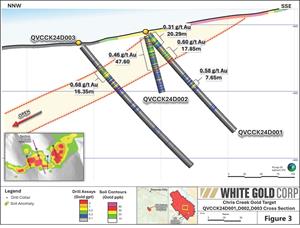
The first three holes of the program, QVCCK24D001 to QVCCK24D003, were drilled on a single cross-section to confirm the interpretation of a moderately NNW-dipping mineralized zone (Figure 3). QVCCK24D001 intersected two separate broad zones of gold mineralization in the upper part of the hole, including 0.31 g/t over 20.29 m from 5.61 m downhole and 0.60 g/t Au over 17.85 m from 39.90 m. Another mineralized interval in the footwall returned 0.58 g/t Au over 7.65 m. QVCCK24D002 was drilled from the same drill pad at a steeper dip (-75°) to confirm the dip of the zone. QVCCK24D002 intersected 0.46 g/t Au over 47.60 m from 6.70 m downhole, including a higher-grade subinterval of 1.43 g/t Au over 4.00 m (see Photo 1) and validated the dip interpretation. QVCCK24D003 was collared approximately 100 m behind holes D001 and D002, intersecting the mineralized zone a further 75 m down-dip. QVCCK24D003 intersected 0.68 g/t Au over 16.35 m from 52.00 m downhole, including a higher-grade subinterval of 1.36 g/t Au over 5.90 m from 60.35 m.
Hole QVCCK24D004 was drilled approximately 130 m east of holes D001 and D002 and intersected gold in the upper half of the hole, grading 0.15 g/t Au over 72.15 m from 23.10 m downhole. QVCCK24D005, the easternmost hole drilled, intersected 0.31 g/t Au over 20.75 m from 55.85 m. Hole QVCCK24D006 was drilled approximately 175 m west of holes D001 and D002, and intersected 0.45 g/t Au over 12.75 m from 38.50 m downhole.
Maiden 2024 diamond drilling at Chris Creek has identified a broad zone of gold mineralization dipping moderately (30°) to the NNW. Gold mineralization is primarily associated with stockwork quartz – tourmaline and carbonate – hematite veins/veinlets hosted within potassically altered hanging wall monzogranite intrusive host rocks. The base of the gold mineralization is marked by a sulphide breccia which occurs at the hanging wall - footwall contact. The breccia consists of 5-20 m thick leached monzogranite crackle breccia with a fine to very fine grained sooty grey pyrite matrix. The unit is consistently bounded at its upper and lower contacts by narrow graphitic faults ranging in thickness from 0.10 - 1.0 m. Anomalous silver (Ag) and tellurium (Te) are associated with gold, with silver ranging from 0.9-2.4 g/t Ag and tellurium from 0.4-1.6 ppm Te within the mineralized intervals. The highest silver and tellurium values are within the footwall mineralized zone intersected in hole QVCCK24D001 which returned 0.58 g/t Au, 6.73 g/t Ag and 3.84 ppm Te over 7.65 m from 102.8 m downhole.
Table 1. Highlights of 2024 Maiden Diamond Drilling Gold Assay Results for the Chris Creek Target.
| Hole ID | From (m) | To (m) | Length (m)* | Au (g/t) |
| QVCCK24D001 | 5.61 | 25.90 | 20.29 | 0.31 |
| and | 39.90 | 57.75 | 17.85 | 0.60 |
| and | 102.80 | 110.45 | 7.65 | 0.58 |
| QVCCK24D002 | 6.70 | 54.30 | 47.60 | 0.46 |
| incl. | 19.00 | 23.00 | 4.00 | 1.43 |
| QVCCK24D003 | 52.00 | 68.35 | 16.35 | 0.68 |
| incl. | 60.35 | 66.25 | 5.90 | 1.36 |
| QVCCK24D004 | 23.10 | 95.25 | 72.15 | 0.15 |
| QVCCK24D005 | 55.85 | 76.60 | 20.75 | 0.31 |
| QVCCK24D006 | 38.50 | 51.25 | 12.75 | 0.45 |
| incl. | 43.00 | 48.00 | 5.00 | 0.79 |
| * Estimated true widths are 100% (D001, D003 to D006) to 90% (hole D002) of core lengths. | ||||
Betty Property
The Betty property is contiguous to and located approximately 40 km east of Newmont Corporation’s Coffee gold deposit (Measured and Indicated Resources of 2.1 Moz gold at 1.28 g/t Au and Inferred Resources of 0.2 Moz gold at 1.04 g/t Au(2)) and 15 km northeast of Western Copper and Gold Corporation’s Casino porphyry deposit (Measured & Indicated Resources of 7.6 Blbs copper and 14.8 Moz gold and Inferred Resources of 3.1 Blb copper and 6.3 Moz gold(3)).
At the Betty property, three targets of the several identified targets on the property were selected for diamond drill testing following a prospectivity analysis and ranking of orogenic gold targets: 1) Black Betty; 2) Betty White East; and 3) Betty Ford (Figure 4). Six holes totalling 1,130.8 m were drilled. A summary of drill collar details is provided in Table 2. Results for each target is provided below. Further testing of these and the other targets on the Betty property is being analyzed as part of the ongoing going exploration planning.
Black Betty
The Black Betty target forms a 700 m-long gold-in-soil anomaly with locally coincident anomalous copper – arsenic – bismuth in soils. The target is located in the western part of the Betty property and immediately overlies the Coffee Creek Fault (CCF), along with second-order NW-trending splays of the CCF. Previous field mapping suggests that gold is hosted within strongly quartz-sericite altered felsic augen gneiss, indicating potential for orogenic gold-hosted mineralization. Historical RAB drilling has been undertaken at the Black Betty target; however, the holes were unable to reach their target depths due to poor ground conditions.
Two holes totalling 400.0 m were drilled at Black Betty, with both holes drilled to the SSW (210° azimuth) at a dip of -50°. Hole BETBLK24D001 tested a northwest-striking secondary fault splay of the CCF associated with a prominent linear magnetic low anomaly, interpreted to possibly represent magnetite destruction related to hydrothermal alteration. The hole intersected a sequence of metasedimentary rocks comprising banded quartzites, schists and gneisses down to 147.05 m. Several narrow (1-4 m wide) faults and shear zones cut this uppermost sequence. A fault/fracture zone at 109.6 – 110.7 m which contains pyrite and arsenopyrite returned the highest-grade gold of the Betty drill program returning 11.6 g/t Au over 1.10 m. The metasedimentary sequence passes downwards into augen gneiss (147.05-175.75 m), and then into predominantly felsic orthogneiss for the remainder of the hole.
Hole BETBLK24D002 was drilled approximately 375 m SW of BETBLK24D001 and was drilled to test the east-west striking CCF in an area with anomalous gold- and bismuth-in-soils. The hole intersected a sequence of metasedimentary gneiss and felsic orthogneiss from surface down to 138.95 m. This sequence is cut by a series of mafic to intermediate dykes up to 6.5 m wide. A major shear and breccia zone was intersected from 138.95 – 182.60 m, which is interpreted to represent the CCF, or possibly a proximal splay. The upper part of the structural zone, from 138.95 – 166.35 m, is dominated by shearing while the lower part, from 166.35 – 182.60 m, comprises what appears to be a tectonic breccia. A narrow zone of gold mineralization was intersected in the hanging wall just above the fault, grading 0.53 g/t Au over 1.60 m from 135.6 m downhole. The remainder of the hole from 182.6 – 200.0 m encountered felsic orthogneiss.
Betty White East
The Betty White East target is located 500 m south of the interpreted eastern extension of the CCF. Anomalous gold- and arsenic-in-soils are associated with WNW striking secondary splay structures in this area, which has previously seen only limited shallow RAB drilling at its eastern margin.
Three holes totalling 543.2 m were drilled at Betty White East with all holes drilled to the SSW (215° azimuth) at a dip of -50°. Hole BETWHE24D001 was drilled to test a linear gold-in-soil anomaly along a NW-trending ridge in the western part of the target area. The hole intersected numerous fault zones ranging in thickness from 5 to 27 m, and the hole was terminated at 104.2 m due to poor ground conditions before reaching the target structure. No significant gold values were encountered.
Holes BETWHE24D002 and BETWHE24D003 were drilled on a single cross-section at the eastern part of the target. BETWHE24D002 intersected a metasedimentary sequence down to 185.3 m, after which it passed into a sequence of felsic orthogneiss and augen gneiss. The upper metasedimentary sequence contains several tectonic breccia zones ranging in width from 0.5 to 10 m. A narrow zone of gold mineralization associated with minor disseminated pyrite in a sericitized and silicified banded quartzite was encountered directly above a 0.5 m breccia zone, returning 1.02 g/t Au over 1.60 m from 154.30 m downhole. Hole BETWHE24D003 was collared approximately 200 m behind (NE) of BETWHE24D002, and intersected a similar metasedimentary sequence as hole BETWHE24D002. Several faults and tectonic breccias were encountered in the upper part of the hole. A single zone of gold mineralization returned 8.78 g/t Au over 0.65 m from 95.2 m downhole. This mineralization is associated with minor disseminated pyrite in a strongly silicified breccia interval.
Betty Ford
Gold mineralization at the Betty Ford target is hosted in a polylithic breccia unit along an east-west striking splay structure located approximately 1.5 km south of and parallel to the Coffee Creek Fault. The target, which forms an approximately 1 km long east-west trending gold-in-soil anomaly with gold values ranging from trace up to 1,961 ppb Au. Gold mineralization at the Betty Ford target is primarily hosted within the oxide and transitional domains of an approximately 100 m-wide polylithic breccia host unit. To date, gold mineralization within these domains has been traced to approximately 75 m vertical depth and 175 m along strike. Highlights from the previous Company drill programs include 3.46 g/t Au over 50.0 m in BETFD21D003, 8.94 g/t Au over 18.29 m in BETFD22RC004, 2.96 g/t Au over 46.5 m in BETFD23D014 and 5.04 g/t Au over 20.85 m in BETFD23D015. See Company press releases dated November 14, 2023 and November 8, 2023 for further details.
A single hole, BETFD24D016 was drilled at the Betty Ford target in 2024. The hole was designed to test the eastern extent of the gold-bearing breccia as it approaches an interpreted NNW-striking cross fault. The hole intersected an upper 8.4 m-wide polylithic breccia unit from 79.70 – 88.10 m and the main polylithic breccia unit from 118.75 – 160.9 m. The main breccia unit is cut by a feldspar porphyry dyke from 138.25 – 146.80 m. Although significant thicknesses of breccia were encountered, all were with in the deeper sulphide domain and no significant gold values were returned. The polylithic breccia is in fault contact at 160.90 m, with an underlying sequence of metasedimentary rocks comprising biotite – quartz – feldspar gneiss, argillite and banded quartzite. This is interpreted to be the NNW-striking cross-fault (Figure 4).
Table 2. Collar details for 2024 Diamond Drill Holes at the QV and Betty properties.
|
Hole Number |
Target |
Collar Location (UTM NAD83 Zone 7) | Azimuth (°) | Dip (°) | Length (m) | ||
| Easting (m) | Northing (m) | Elevation (m) | |||||
| QV Property | |||||||
| QVCCK24D001 | Chris Creek | 569,013 | 7,022,692 | 590 | 160 | -50 | 200.0 |
| QVCCK24D002 | Chris Creek | 569,013 | 7,022,692 | 590 | 160 | -75 | 95.0 |
| QVCCK24D003 | Chris Creek | 568,978 | 7,022,786 | 584 | 160 | -50 | 251.0 |
| QVCCK24D004 | Chris Creek | 569,144 | 7,022,680 | 631 | 180 | -50 | 167.0 |
| QVCCK24D005 | Chris Creek | 569,222 | 7,022,830 | 608 | 160 | -50 | 193.0 |
| QVCCK24D006 | Chris Creek | 568,838 | 7,022,683 | 565 | 160 | -50 | 176.0 |
| QV - Total | 6 holes | 1,082.0 | |||||
| Betty Property | |||||||
| BETBLK24D001 | Black Betty | 619,778 | 6,966,565 | 1,026 | 210 | -50 | 200.0 |
| BETBLK24D002 | Black Betty | 619,509 | 6,966,303 | 928 | 210 | -50 | 200.0 |
| BETWHE24D001 | Betty White East | 625,461 | 6,965,060 | 651 | 215 | -50 | 104.2 |
| BETWHE24D002 | Betty White East | 626,726 | 6,964,722 | 596 | 215 | -50 | 239.0 |
| BETWHE24D003 | Betty White East | 626,830 | 6,964,886 | 618 | 215 | -50 | 200.0 |
| BETFD24D016 | Betty Ford | 624,772 | 6,963,552 | 878 | 30 | -60 | 187.6 |
| Betty - Total | 6 holes | 1,130.8 | |||||
QA/QC
White Gold’s drill core sampling consisted of collecting samples over 0.50 m to 2.50 m intervals (depending on lithology and style of mineralization) over the entire hole length. RC samples were collected at continuous 1.5 m intervals. All drill core was cut in half using a diamond saw, with half of the core placed in sample bags and the other half returned to the core box. Standard, blank, and duplicate samples were inserted into both the drill core and RC sample streams at regular intervals to meet a designated QA/QC sample insertion rate. All samples were organized into batches, flown via fixed-wing aircraft from camp, and transported via courier to an ISO-certified laboratory for analysis.
Qualified Person
Terry Brace, P.Geo. and Vice President of Exploration for the Company is a “qualified person” as defined under National Instrument 43-101 – Standards of Disclosure of Mineral Projects and has reviewed and approved the content of this news release.
About the QV Property & Chris Creek Target
The QV property comprises 1003 quartz claims which over an area of 19,671 hectares and hosts the VG deposit, which hosts an open pittable Inferred resource of 295,500 oz gold at 1.47 g/t(1) and forms part of the Company’s flagship White Gold Project. Mineralization at the VG deposit is hosted along a northeast trending, gently south dipping structural zone that has been traced for over 700 m at surface and consists of disseminated to vein-controlled pyrite with brecciation, stockwork quartz-carbonate veining, and sericite alteration. The VG deposit shares strong similarities to the Golden Saddle deposit located 11 km to the south on the White Gold property in terms of structural setting as well as mineralization style. The property also hosts several other prospective targets which have received limited exploration work and offer potential for additional discoveries.
The Chris Creek target represents a prospective new target located approximately 9 km northwest of the VG deposit. In 2024 soil geochemical sampling at the target returned values as high as 600 ppb Au, including 418.6 ppb Au, 244.6 ppb Au, 237.3 ppb Au, 218.1 ppb Au, and 200.6 ppb Au. These results further define the core of the anomaly and expand the gold-in-soil trend eastward toward the Diego trend. This connection forms an overall gold trend measuring roughly 2.7 km along strike and up to 250 m in width.
The geological features of Chris Creek closely resemble those of the Golden Saddle and VG deposits, all of which remain open for expansion. At Golden Saddle and VG, gold is hosted within brittle-ductile fault zones, quartz vein breccias, and stockwork veining, similar to the structures seen at Chris Creek. Initial rock sampling results suggest Chris Creek shares many of the same features as the Golden Saddle and VG deposits. The strong similarities between Chris Creek, which remains underexplored and open for expansion, and the established Golden Saddle and VG deposits, represent substantial potential for future discoveries within the Chris Creek system. With multiple mineralization styles (Au-Te-Ag, As-Sb, Mo-bearing quartz-carbonate veins, and skarn) across a large structural corridor, there is significant opportunity for continued geophysical surveys, trenching, and drilling to further define and expand the mineralized zones.
About White Gold Corp.
The Company owns a portfolio of 15,319 quartz claims across 21 properties covering approximately 300,000 hectares (3,000 km2) representing approximately 40% of the Yukon’s emerging White Gold District. The Company’s flagship White Gold project hosts four near-surface gold deposits which collectively contain an estimated 1,203,000 ounces of gold in Indicated Resources and 1,116,600 ounces of gold in Inferred Resources (this news release). Regional exploration work has also produced several other new discoveries and prospective targets on the Company’s claim packages which border sizable gold discoveries including the Coffee project owned by Newmont Corporation with Measured and Indicated Resources of 2.1 Moz at 1.28 g/t gold and Inferred Resources of 0.2 Moz at 1.04 g/t gold(2), and Western Copper and Gold Corporation’s Casino project which has Measured and Indicated Resources of 7.6 Blb copper and 14.5 Moz gold and Inferred Resources of 3.3 Blb copper and 6.6 Moz gold(3). For more information visit www.whitegoldcorp.ca.
(1) See White Gold Corp. technical report titled “2024 Technical Report for the White Gold Project, Dawson Range, Yukon, Canada”, Effective Date October 28, 2024, Report Date January 3, 2025, NI 43-101 Compliant Technical Report prepared by Dr. Gilles Arseneau, P.Geo. of ARSENEAU Consulting Services Inc. (“ACS”), available on SEDAR+.
(2) See Newmont Corporation Form 10-K: Annual report for the year ending December 31, 2023, in the Measured, Indicated, and Inferred Resources section, dated February 29, 2024, available on EDGAR. Reserves and resources disclosed in this Form 10-K have been prepared in accordance with the Regulation S-K 1300, and do not indicate NI43-101 compliance.
(3) See Western Copper and Gold Corporation technical report titled “Casino project, Form 43-101F1 Technical Report Feasibility Study, Yukon Canada”, Effective Date June 13, 2022, Issue Date August 8, 2022, NI 43-101 Compliant Technical Report prepared by Daniel Roth, PE, P.Eng., Mike Hester, F Aus IMM, John M. Marek, P.E., Laurie M. Tahija, MMSA-QP, Carl Schulze, P.Geo., Daniel Friedman, P.Eng., Scott Weston, P.Geo., available on SEDAR+.
Cautionary Note Regarding Forward Looking Information
This news release contains “forward-looking information” and “forward-looking statements” (collectively, “forward-looking statements”) within the meaning of the applicable Canadian securities legislation. All statements, other than statements of historical fact, are forward-looking statements and are based on expectations, estimates and projections as at the date of this news release. Any statement that involves discussions with respect to predictions, expectations, beliefs, plans, projections, objectives, assumptions, future events or performance (often but not always using phrases such as “expects”, or “does not expect”, “is expected”, “anticipates” or “does not anticipate”, “plans”, “proposed”, “budget”, “scheduled”, “forecasts”, “estimates”, “believes” or “intends” or variations of such words and phrases or stating that certain actions, events or results “may” or “could”, “would”, “might” or “will” be taken to occur or be achieved) are not statements of historical fact and may be forward-looking statements. In this news release, forward-looking statements relate, among other things, the Company’s objectives, goals and exploration activities conducted and proposed to be conducted at the Company’s properties; future growth potential of the Company, including whether any proposed exploration programs at any of the Company’s properties will be successful; exploration results; and future exploration plans and costs and financing availability.
These forward-looking statements are based on reasonable assumptions and estimates of management of the Company at the time such statements were made. Actual future results may differ materially as forward-looking statements involve known and unknown risks, uncertainties and other factors which may cause the actual results, performance or achievements of the Company to materially differ from any future results, performance or achievements expressed or implied by such forward-looking statements. Such factors, among other things, include: The expected benefits to the Company relating to the exploration conducted and proposed to be conducted at the White Gold properties; the receipt of all applicable regulatory approvals for the Offering; failure to identify any additional mineral resources or significant mineralization; the preliminary nature of metallurgical test results; uncertainties relating to the availability and costs of financing needed in the future, including to fund any exploration programs on the Company’s properties; business integration risks; fluctuations in general macroeconomic conditions; fluctuations in securities markets; fluctuations in spot and forward prices of gold, silver, base metals or certain other commodities; fluctuations in currency markets (such as the Canadian dollar to United States dollar exchange rate); change in national and local government, legislation, taxation, controls, regulations and political or economic developments; risks and hazards associated with the business of mineral exploration, development and mining (including environmental hazards, industrial accidents, unusual or unexpected formations pressures, cave-ins and flooding); inability to obtain adequate insurance to cover risks and hazards; the presence of laws and regulations that may impose restrictions on mining and mineral exploration; employee relations; relationships with and claims by local communities and indigenous populations; availability of increasing costs associated with mining inputs and labour; the speculative nature of mineral exploration and development (including the risks of obtaining necessary licenses, permits and approvals from government authorities); the unlikelihood that properties that are explored are ultimately developed into producing mines; geological factors; actual results of current and future exploration; changes in project parameters as plans continue to be evaluated; soil sampling results being preliminary in nature and are not conclusive evidence of the likelihood of a mineral deposit; title to properties; and those factors described under the heading “Risks Factors” in the Company’s annual information form dated July 29, 2020 available on SEDAR+. Although the forward-looking statements contained in this news release are based upon what management of the Company believes, or believed at the time, to be reasonable assumptions, the Company cannot assure shareholders that actual results will be consistent with such forward-looking statements, as there may be other factors that cause results not to be as anticipated, estimated or intended. Accordingly, readers should not place undue reliance on forward-looking statements and information. There can be no assurance that forward-looking information, or the material factors or assumptions used to develop such forward-looking information, will prove to be accurate. The Company does not undertake to release publicly any revisions for updating any voluntary forward-looking statements, except as required by applicable securities law.
Neither the TSXV nor its Regulation Services Provider (as that term is defined in the policies of the TSXV) accepts responsibility for the adequacy or accuracy of this news release.
For Further Information, Please Contact:
Contact Information:
David D’Onofrio
Chief Executive Officer
White Gold Corp.
(647) 930-1880
ir@whitegoldcorp.ca
Request Meeting: https://calendly.com/meet-with-wgo/15min
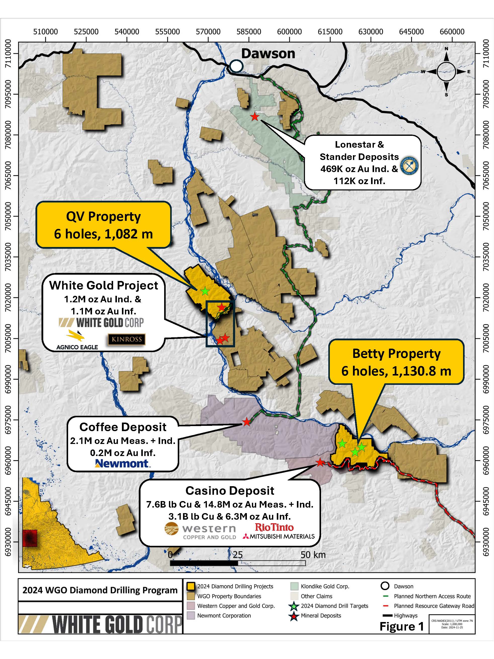 Figure 1
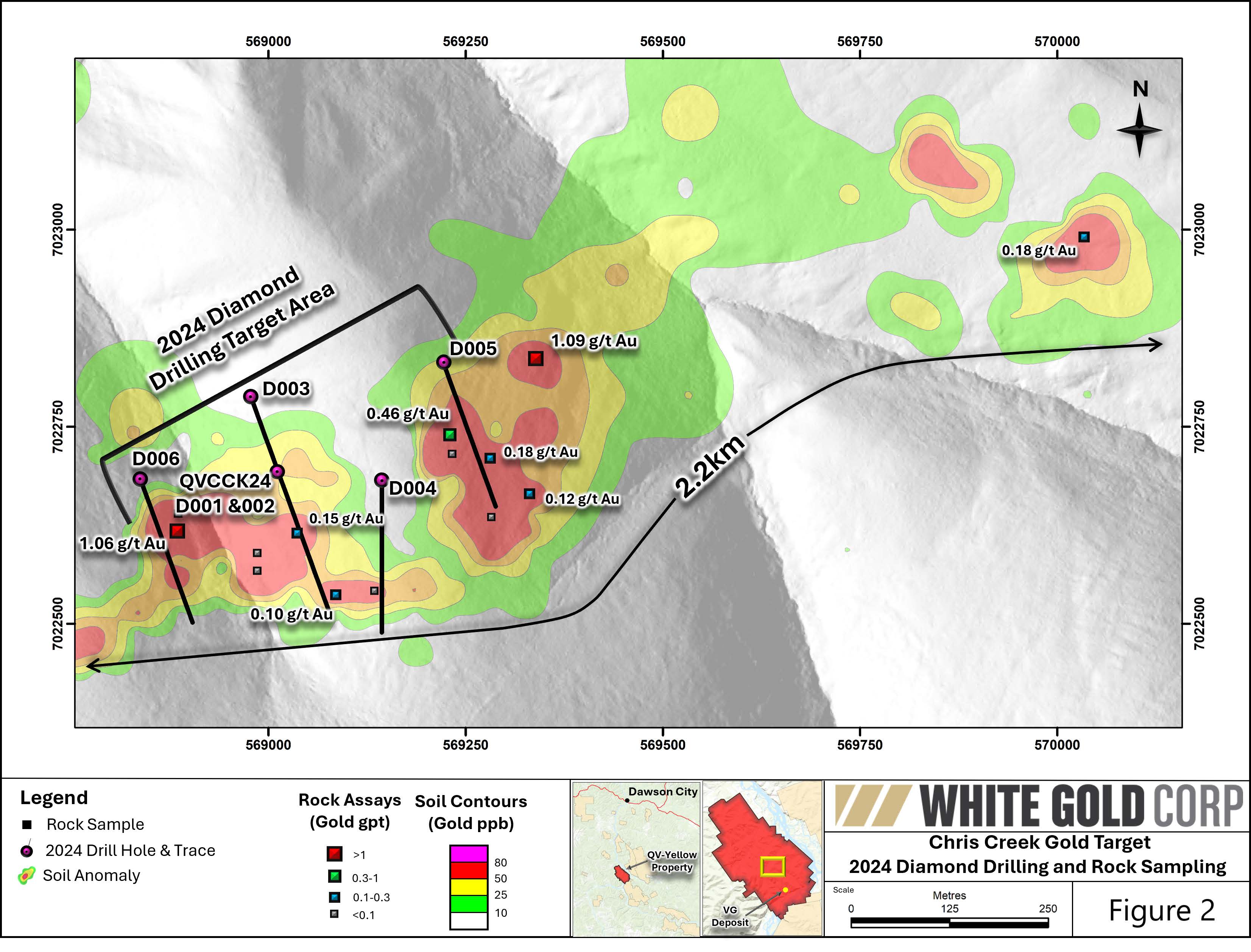
Figure 2

Figure 3
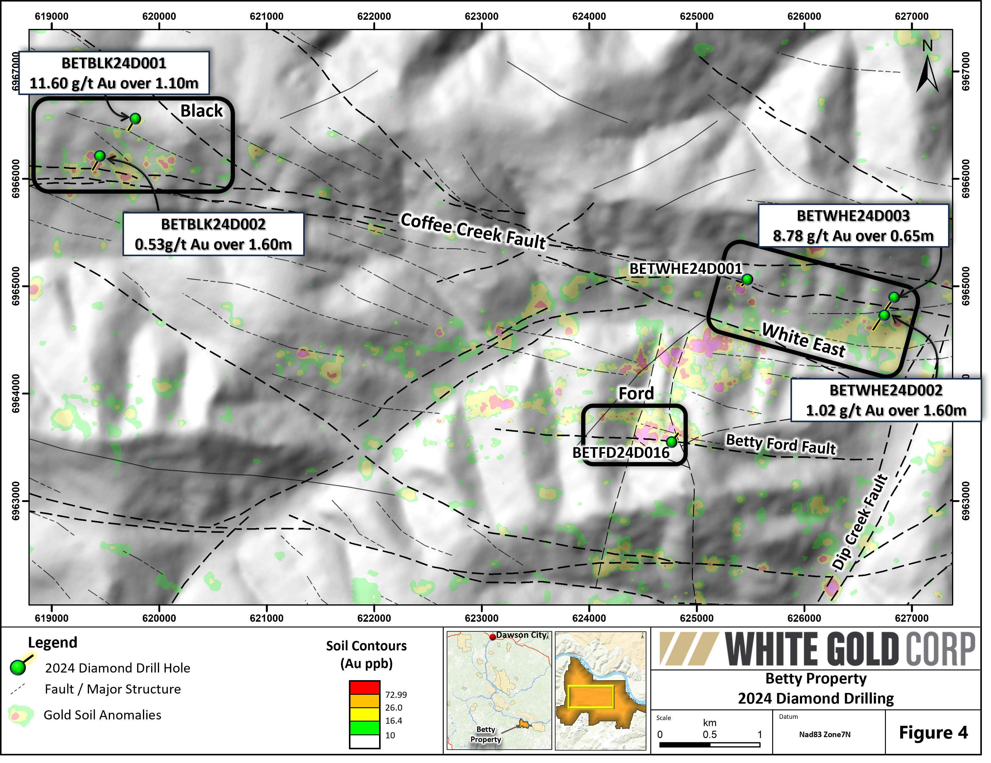
Figure 4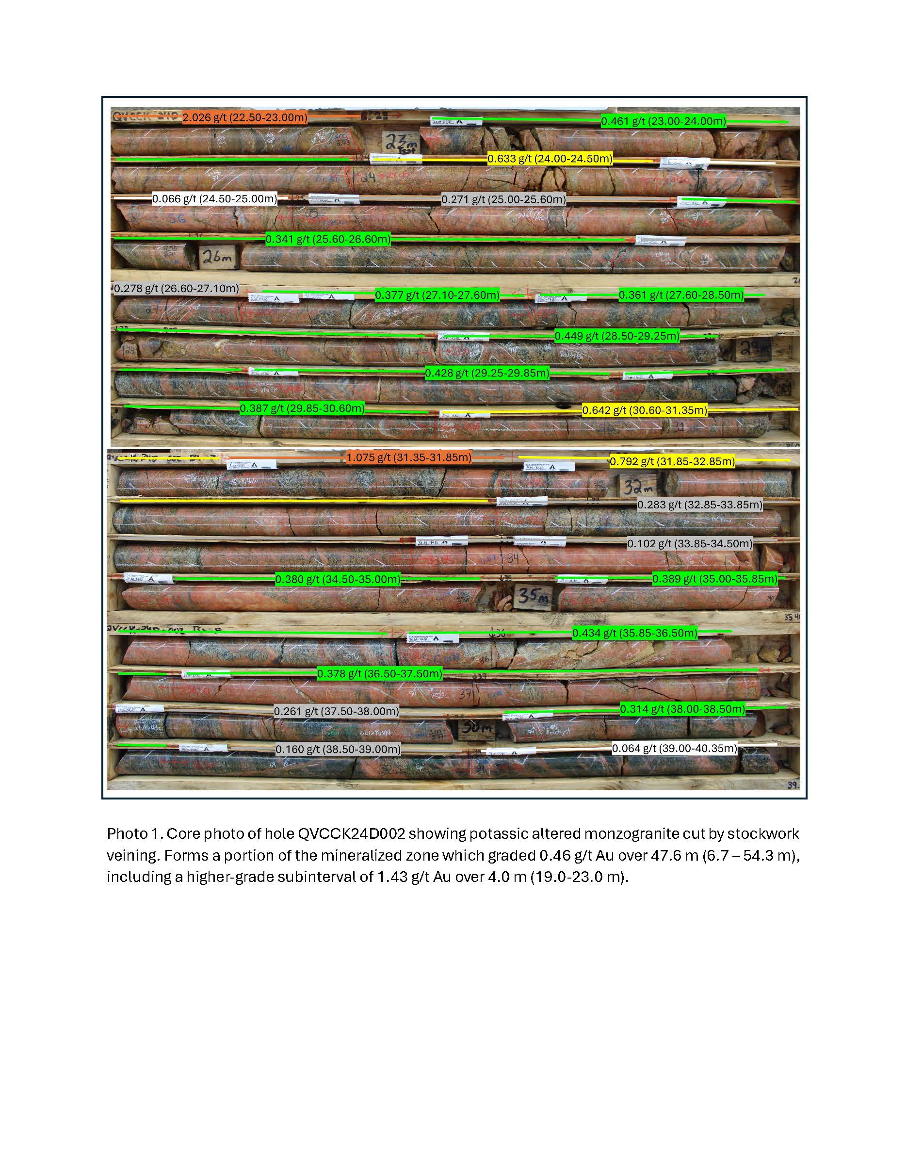
Photo 1
Figures accompanying this announcement are available at
https://www.globenewswire.com/NewsRoom/AttachmentNg/20ddb124-59c7-4676-b3b5-49992133d8b6
https://www.globenewswire.com/NewsRoom/AttachmentNg/12586ea2-2215-4255-a9ca-55fde4caa3ea
https://www.globenewswire.com/NewsRoom/AttachmentNg/c5e4f330-f3f2-4acf-8170-b54b5bc85a6d
https://www.globenewswire.com/NewsRoom/AttachmentNg/c58dc0c0-1883-47cf-8719-a7470a1eed12
https://www.globenewswire.com/NewsRoom/AttachmentNg/46d93c86-2e63-4ae8-b635-b63620f30057

![]()
Figure 1
Location Map
Figure 2
2024 Chris Creek Plan Map
Figure 3
Chris Creek Cross-Section
Figure 4

Betty 2024 Drilling Plan Map
Photo 1
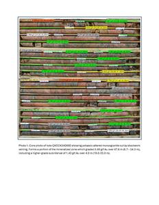
Core photo of hole QVCCK24D002 showing potassic altered monzogranite cut by stockwork veining. Forms a portion of the mineralized zone which graded 0.46 g/t Au over 47.6 m (6.7 – 54.3 m), including a higher-grade subinterval of 1.43 g/t Au over 4.0 m (19.0-23.0 m).
Distribution channels: Media, Advertising & PR, Mining Industry ...
Legal Disclaimer:
EIN Presswire provides this news content "as is" without warranty of any kind. We do not accept any responsibility or liability for the accuracy, content, images, videos, licenses, completeness, legality, or reliability of the information contained in this article. If you have any complaints or copyright issues related to this article, kindly contact the author above.
Submit your press release